* Cartes / Map
| Medium: | Etching |
| Dimensions (paper): | 38.0 x 52.0 cm |
| Paper Type: | Vélin d'Arches |
| Date of Edition: | 1990 |
| Price: | $200.00 |
| Signed Copies: | 1-200 |
| Reference: | mach-01 |
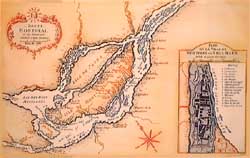
Note: Originally by Nicolas Bellin, it is the last map of Montreal under the French Regime. It was created during the time between the conquest by British troops (1760) and the Treaty of Paris (1763).
The insert is a plan of Ville-Marie (original name of the city of Montreal).
This copy of a genuine map was printed by master-printer Paul Machnik in his workshop, Montreal.