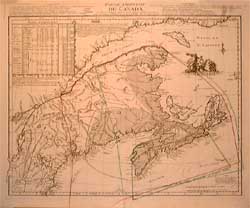
* Cartes / Map
| Medium: | Etching (mix media) |
| Dimensions (paper): | 53.0 x 77.0 cm |
| Date of Edition: | 1755 |
| Price: | $0.00 |
| Signed Copies: | Monotype |
| Reference: | C98-02 |
Note: Eastern part of Canada - 1755
By M. Le Rouge (translated from Jeffery's map)
"Traduite de l'Anglois de la Carte de Jeffreys
publiée à Londres en may 1755, à Paris, par le Sr. Le Rouge, ingénieur-géographe du Roy, Paris, rue des Augustins".
Le Rouge described clearly the conflictual boundaries between the colonial states of the era. Details are provided in three different languages: french, english and german. Interesting comparison between various locations and their longitude and latitude taken from different former maps.
Please contact us for prices.