|
|
 |
 |
 Old Maps & Old Prints
|
 |
Now that you have chosen a theme, just click on one of the artists, listed on the left side of the page, to see that artist's section. In addition, you can view biographical information for several of our artists by clicking on that artist's name.
NOTE: If you are looking for a particular piece, you can search our entire catalog with our advanced search. Click the Search button at the top of the page. |
List of Artists
* Cartes / Map
*Actions Anciennes
Bartlett, W. H.
|
|
* Cartes / Map
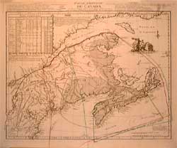 |
Eastern part of Canada, Jefferys - 1755
* Cartes / Map
| Medium: |
Etching (mix media) |
| Dimensions (paper): |
53.0 x 77.0 cm |
| Date of Edition: |
1755 |
| Price: |
$0.00 |
| Signed Copies: |
Monotype |
| Reference: |
C98-02 |
| |
 |
|
Note: Eastern part of Canada - 1755
By M. Le Rouge (translated from Jeffery's map)
"Traduite de l'Anglois de la Carte de Jeffreys
publiée à Londres en may 1755, à Paris, par le Sr. Le Rouge, ingénieur-géographe du Roy, Paris, rue des Augustins".
Le Rouge described clearly the conflictual boundaries between the colonial states of the era. Details are provided in three different languages: french, english and german. Interesting comparison between various locations and their longitude and latitude taken from different former maps.
Please contact us for prices.
|
|
|
|
|
|
|
|
|